... as my ever wise father is known to say. Although to be fair, even he didn't expect a vw campervan... ;)
So when you think of Greece, you probably think either islands, beaches, all night partying and blazing sun, or ancient ruins, bleached white sugar-cube buildings, blue domed temples and blazing sun. What you don't necessarily think of, is blue lakes, rolling green hills, slate grey perched villages, deep rocky canyons and snow capped mountains. Which is what we have found so far. Oh, and blazing sun of course :)


And so a lazy day or so was spent overcoming our boat-lag (just doesn't have the same ring to it!) and Will also found the last bits he needed from a pc-world-u-like high street shop for his new mini project - better in-van wifi. The requested pigtail turned out to be not quite the right solution but thanks to Kiri we now have a big external wifi antenna and some coax and Will has soldered these to a new usb stick thing and bingo! better wifi signal - excellent!
And he got the oil changed at last too - and what a pretty spot to do it too. Still looking for somewhere to safely get rid of the old oil but better carrying it in an oil bottle than in the engine! Thank you Jim and Elissa!


Next stop, Zagori, an area of the Pindos mountains to the north of Ioannina, famous for its forests, rivers, snow capped mountains, and particularly; the Vikos Gorge which cuts through it, the Zagorohoria, 46 slate-grey, perched villages, nestled in its heights and the slender, arching stone bridges on the paths which wend their way between them.
The LP had indicated that the paths through the gorge were well signed but that Ioannina tourist office could provide more information... Unfortunately only sort of right on both counts.
We ended up with a regional map - which was extremely useful but only in greek - and a regional brochure which had pictures but was only in italian... And nothing specific on the Zagori in either, just a few pictures and some descrptions in italian.

But we set off anyway and my ability to recognise road signs and translate latin to greek characters on road signs at speed has improved immensely!
 We found Monodendri easily enough, a pretty little hillside village - mainly cafes and tavernas and small hotels but charming nonetheless - and being late in the day set off on the 600m walk to the Ayia Paraskevi monastery.
This was well signed, an easy, newly laid stone track, to the little chapel building

and beyond that, a less obvious path pointed towards the 'Big Cave' and 'Old Bridge'. Well why not.
The path was a vertigo sufferer's worst nightmare.


 No more than about a foot wide in places, hewn in the the rock, about two thirds of the way up a sheer cliff face - brilliant!
We didn't find anything bridge-like - unless it was the two small sections which had either crumbled or washed away and were covered over with distinctly flaky looing planks...
- and the 'cave' was more like a once fortified depression in the cliff face,

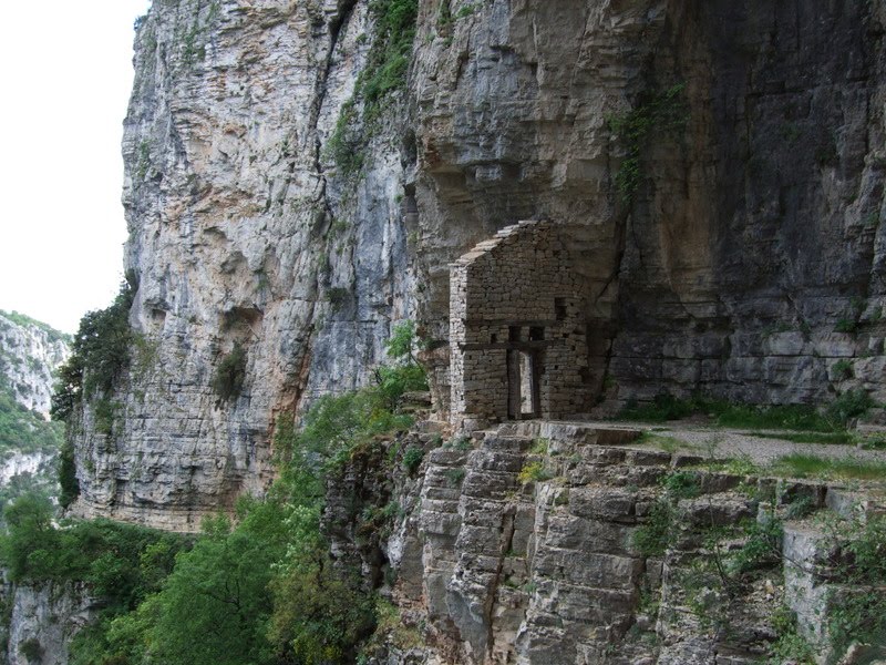
but pretty cool nonetheless. We would have gone further but figured this was where the path ran out - I know, no sense of adventure... ;)


So, back to the van for a cup of tea - too cheap for coffee this week having spent all next week's budget on ferry tickets already! - and a bit of a sit, a bit of a stroll round town, then suddenly it was late - this new timezone is a bit of a killer. we don't really use clocks and in Croatia had got used to cooking at about 7:30 because a) that's dinner time, and b)that's when it starts getting dark so when you are illegally camping and trying to be discrete, it is either cook then or cook later in total darkness, which is not so good.
Here though, it is suddenly 9pm when it's starting to get dark, and wild camping is ok so you can have the lights on, which means by the time you've got your act together, its getting very late.
It seems though, that wild camping is so not an issue that not only can you stop in any old layby or gravel patch by the side of the road, you can get your table, chairs and table top oven out (it was either that or a beer keg) and make yourself right at home - well you can if you're german anyway...


Anyway. Having decided that a 'strenuous 7h hour hike' to the twin perched villages on Megalo Papingo and Mikro Papingo was a bit beyond us, we opted for the 2h, 5km walk to somewhere else - sounded more our level. So we headed down the steep path, down which all routes were signposted, and didn't see another sign thereafter.
We did, during the day, see some spray painted arrows to somewhere else we didn't want to go, follow some painted splodges which initially looked promising and then disappeared and meet three other sets of people, none of whom seemed to have any idea where the path was either so it wasn't just us being useless!
But a happy afternoon was spent wandering the woods deep in the canyon and hopping from boulder to boulder across rushing bits of stream to zigzag our way over the river - all good fun!


Onwards and outwards once more, we decided against a long drive north to the Papingos - i'm sure they're very lovely but the lp only had tavernas and small hotels to say about them, as well as the fact that they are very high up, and a fuel consuming trip to places we can't afford to give any custom to, just didn't see worth it with petrol up here at €1.55/l *wince*
So we set off in search of bridges instead, and, given that we only had a very vague map and descriptions in Italian, I think we did quite well!

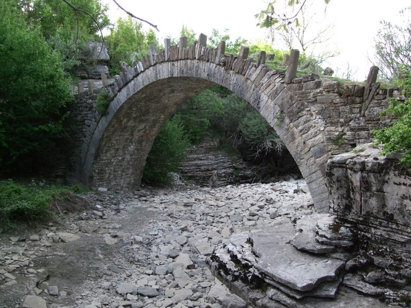 Captain Arkouda's Bridge

Kokori's Bridge
Bridge of Milos


a tiny tiny one

We even found the most iconic one, Plakidas (or Kalogeriko) in Kipi, which is unique in that it has 3 arches - although to be fair we only found it by getting ourselves to what we believed to be the right village and then buying a postcard so we could ask the shopowner where the bridge was...

We stopped for the night, high above the gorge - breathtaking -


 and headed to the famous bridge in the bright sunshine, where we met Leaning Peter and his fellow band of travelling french canadians and stopped for a chat about all things travel.
All the while, surrounded by butterflies


 and the heights of the Katara Pass. where they seemed very keen you always knew where your next snow plow station was!


Not finished yet - on either count! - but I did get my first greek daisies on the driver's side of the van before the sun disappeared behind a hill like someone flicking of a light switch.
And so here we are. Miles from anywhere, on top of the world. Marvelous.


ttfn

No comments:
Post a Comment